READING HALLTHE DOORS OF WISDOM |
 |
 |
 |
PRINCEHENRY THE NAVIGATOR1394-1460THE HERO OF PORTUGAL AND OF MODERN DISCOVERY.WITH AN ACCOUNT OF GEOGRAPHICAL PROGRESS THROUGHOUT THE MIDDLE AGES AS THE PREPARATION FOR HIS WORKBY
C. RAYMOND BEAZLEY1894
The Lusitanian Prince who,
heaven-inspired, Thomson: Seasons, Summer, 1010-2.
THE
|
VOLUME I |
VOLUME II |
VOLUME III |
VOLUME I |
VOLUME II |
Arabic science constitutes one of the main links
between the older learned world of the Greeks and Latins and the Europe of
Henry the Navigator and of the Renaissance. In geography it adopted in the main
the results of Ptolemy and Strabo; and many of the Moslem travellers and writers gained some additional hints from Indian, Persian, and Chinese
knowledge; but, however much of fact they added to Greek cartography, they did
not venture to correct its postulates.
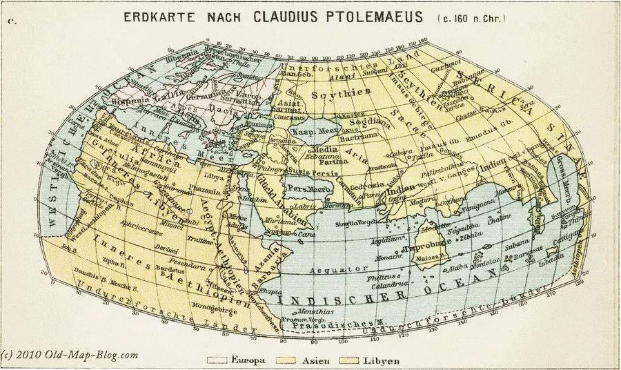
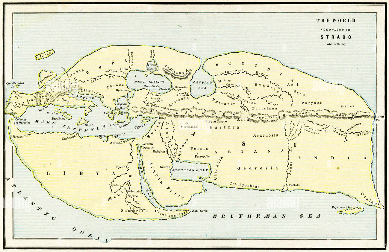
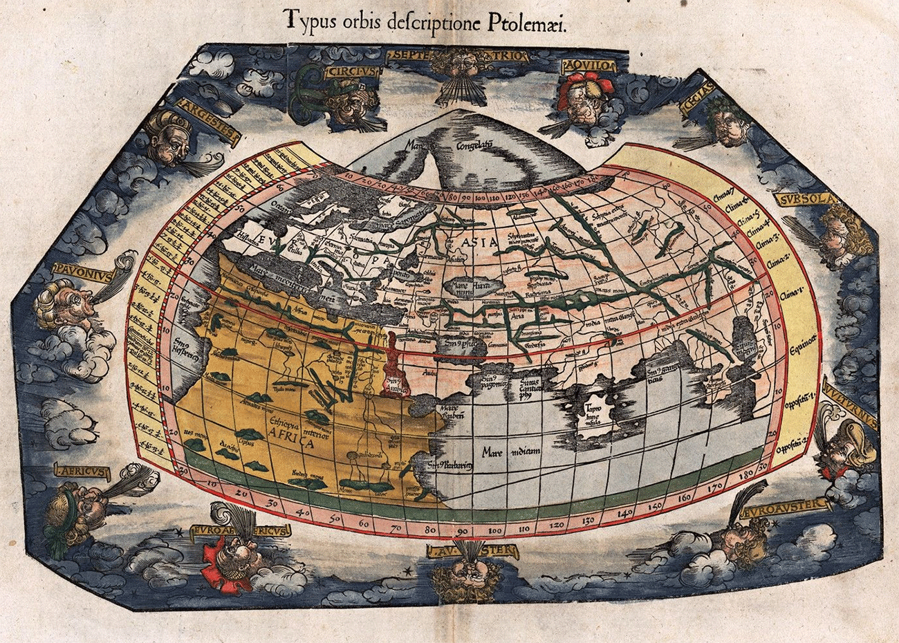
And what were these postulates? In part, they were the assumptions of modern draughtsmen, but in some important details they differed. And first, as to agreement. Three continents, Europe, Asia, and Africa, an encircling ocean, the Mediterranean, the Black Sea and Caspian, the Red Sea and Persian Gulf, the South Asiatic, and North and West European coasts were indicated with more or less precision in the science of the Antonines and even of Hannibal's age. Similarly, the Nile and Danube, Euphrates and Tigris, Indus and Ganges, Jaxartes and Oxus, Rhine and Ebro, Don and Volga, with the chief mountain ranges of Europe and Western Asia, find themselves pretty much in their right places in Strabo's description, and are still better placed in the great chart of Ptolemy. The countries and nations from China to Spain are arranged in the order of modern knowledge. But the differences were fundamental also. Never was there a clearer outrunning of knowledge by theory, science by conjecture, than in Ptolemy's scheme of the world (c. a.d. 130). His chief predecessors, Eratosthenes and Strabo, had left much blank space in their charts, and had made many mistakes in detail, but they had caught the main features of the Old World with fair accuracy. Ptolemy, in trying to fill up what he did not know from his inner consciousness, evolved a parody of those features. His map, from its intricate falsehood, backed as it was by the greatest name in geographical science, paralysed all real enlargement of knowledge till men began to question, not only his facts, but his theories. And as all modern science, in fact, followed the progress of world-knowledge, or geography, we may see how important it was for this revolution to take place, for Ptolemy to be dethroned.
THE WORLD ACCORDING PTOLEMY
 |
The Arabs, commanding most of the centres of ancient learning (Ptolemy's own Alexandria above all), riveted the
pseudo-science of their predecessors on the learned world, along with the
genuine knowledge which they handed down from the Greeks. In many details they
corrected and amplified the Greek results. But most of their geographical
theories were mere reproductions of Ptolemy's, and to his mistakes they added
wilder though less important confusions or inventions of their own. The result
of all this, by the tenth century A.D., was a geography, based not on
knowledge, but on ideas of symmetry. It was a scheme fit for the Arabian
Nights.
And how did Ptolemy lend himself to this?
His chief mistakes were only two;—but they were
mistakes from which at any rate Strabo and most of the Greek geographers are
free. He made the Indian Ocean an inland sea, and he filled up the Southern
Hemisphere with Africa, or the unknown Antarctic land in which he extended
Africa. The Dark Continent, in his map, ran out on the one side to the
south-east of China, and on the other to the indefinite west, though there was
here no hint of America or an Atlantic continent. It was a triumph of learned
imagination over humdrum research. Science under Hadrian was ambitious to have
its world settled and known; it was not yet settled or fully known; and so a
great student constructed a mélange of fact and fancy mainly based on a
guess-work of imaginary astronomical reckonings. On the far east, Ptolemy
joined China and Africa; and on this imaginary western coast, fronting Malacca
and Further India, he placed various gratuitous towns and rivers. Coming to
smaller matters, he cut away the whole of the Indian peninsula proper, though
preserving the Further or”Golden” Chersonesus of the Malays, and he enlarged Taprobane, or Ceylon,
to double the size of Asia Minor. Thus the southern coast of Asia from Arabia
to the Ganges ran almost due east, with a strait of sea coming through the
modern Carnatic, between the continent and the Great Spice Island, which
included most of the Deccan. The Persian Gulf, much greater on this map than
the Black Sea, was made equal in length and breadth; the shape of the Caspian
was, so to say, turned inside out and its length given as from east to west,
instead of from north to south; while the coast line, even of the familiar
Euxine, Aegean, and Southern Mediterranean, was anything but true. Scandinavia
was an island smaller than Ireland; Scotland represented a great eastern bend
of Britain, with the Shetlands and Färoes (Thule) lying a short distance to the
north, but on the left-hand side of the great island. The Sea of Azov, hardly
inferior to the Euxine, stretched north half way across Russia. All Central
Africa and the great Southern or Antarctic continent was described as pathless
desert—"a land uninhabitable from the heat”; and the sources of the Nile
were accounted for by the marshes and Mountains of the Moon.
Thus all the problems of ancient geography were
explained: where Ptolemy’s knowledge failed him altogether, no Western of that
time had ever been, or was likely to go. The whole realised and unrealised world was described with such
clearness and consistency, men thought, that what was lacking in Aristotle was
now supplied.
Yet it is worthwhile observing how, centuries before
Ptolemy, in the ages nearer to Aristotle himself, the geography of Eratosthenes
and Strabo, by a more balanced use of knowledge and by a greater restraint of
fancy, had composed a far more reliable chart.
This earlier and discredited map avoided all the more
serious perversions of Ptolemy. Africa was cut off at the limit of actual
knowledge, about Cape Non on the west and Cape Guardafui on the east; and the “Cinnamon-bearing Coast”, between these points, was
fringed by the Mountains of Ethiopia, where the Nile rose. This was the theory
which revived on the decline of the Ptolemaic, and which encouraged the
Portuguese sailors with hopes of a quick approach to India round Africa, as the
great eastern bend of the Guinea coast seemed to suggest. Further, on this
pre-Ptolemaic map the Southern Ocean was left untouched by a supposed Southern
Continent, and except for an undue shrinkage of the Old World in general as an
island in the midst of the vast surrounding ocean, a reliable description of
Western Asia and Central Europe and North Africa was in the hands of the
learned world two hundred years before Christ.
It is true that Strabo’s China is cramped and cut
short; that his Ceylon (Taprobane) is even larger
than Ptolemy's; that Ireland (Ierne) appears to the
north of Britain; and that the Caspian joins the North Sea by a long and narrow
channel; but the true shape of India, of the Persian Gulf and the Euxine, of
the Sea of Azov and the Mediterranean, is marked rightly enough in general
outline. This earlier chart has not the elaborate completeness of Ptolemy's,
but it is free from his enormous errors, and it has all the advantage of
science, however imperfect, over brilliant guessing.
Of course, even in Ptolemy, this guess-work pure and
simple only comes in at intervals and does not so much affect the central and,
for his day, far more important tracts of the Old World, but we have yet to see
how, in the medieval period and under Arabic imagination, all geography seemed
likely to become an exercise of fancy.
The chief Greek descriptions of the world, we must
clearly remember, were before the medieval workers, Christian and Moslem, from
the first; these men took their choice, and the point is that they, and
specially the Arabs, chose with rare exceptions the last of these, the
Ptolemaic system, because it was the more ambitious, symmetrical, and pretty.
Let us trace for a moment the gradual development of
this geographical mythology.
Starting with the notion of the world as a disc, or a
ball, the centre of the universe, round which moved
six celestial circles, of the Meridian, the Equator, the Ecliptic, the two
Tropics, and the Horizon, the Arab philosophers on the side of the earth’s
surface worked out a doctrine of a Cupola or Summit of the world, and on the
side of the heavens a pseudo-science of the Anoua or
Settings of the Constellations, connected with the twelve Pillars of the Zodiac
and the twenty-eight Mansions of the Moon.
With Arabic astrology we are not here concerned; it is
only worth noting in this connection as the possible source of early Christian
knowledge of the Southern Cross and other stars famous in the story of
exploration, such as Dante shows in the first canto of his Purgatorio.
But the geographical doctrines of Islam, compounded from the Hebrew Pentateuch
and the theoretical parts of Ptolemy, had a more immediate and reactionary
effect on knowledge. The symmetrical Greek divisions of land into seven zones
or climates; and of the world's surface, into three parts water and one part terra firma; the Indian fourfold arrangement of “Romeland” and the East; the similar fourfold Chinese
partition of China, India, Persia, and Tartary: all these reappeared confusedly
in Arabic geography. From India and the Sanscrit “Lanka”,
they seem to have got their first start on the myth of Odjein, Aryn, or Arim, “the World's
Summit”; from Ptolemy the sacred number of 360 degrees of longitude was
certainly derived, beautifully corresponding to the days of the year, and
neatly divided into 180 of land or habitable earth and 180 of sea, or
unharvested desert. With the seven climates they made correspond the great
Empires of the world—chief among which they reckoned the Caliphate (or Bagdad),
China, Rome, Turkestan, and India.
The sacred city of Odjein had been the centre of most of the earlier Oriental
systems; in the Arabic form of Arim (“The Cupola of
the Earth”), it became the fixed point round which circled medieval theories of
the world’s shape. “Somewhere in the Indian Ocean between Comorin and
Madagascar”, became the compromise when the mountain could not be found off any
of the known coast-lines; it was mixed up with notions of the Roc, and the Moon
Mountains in Africa, of the Magnet Island and of the Eastern Kingdom made out
of one vast pearl; and even in Roger Bacon it serves as an algebraic sign for a
mathematical centre of the world.
The enlargement of knowledge, though forcing upon
Arabic science a conviction of Ptolemy's mistake in over-extending the limits
of the world known to him, only led to the invention of a scholastic
distinction between the real and the traditional East and West, while the
confusion was made perfect by the travestied history always so popular among
Orientals. The “Gades of Alexander and Hercules”, the
farthest points east and west, were named after the mythical conquests of the
real Iskander and the mythical hero of Greeks and Phœnicians. Arim in the middle, with the pillars of Hercules and
Alexander, and the north and south poles at equal distance from it—the centre and the four corners of the world as neatly fixed as
geometry could define—this was the map, first of the Arabs, and then of their
Christian scholars.
To form any idea of the complete spell thus cast over
thought both in Islam and Christendom, we may look at the words of European
scholars of the twelfth and thirteenth centuries, living far from Islam, long
after its intellectual glory had begun to decay, and at a time when Christian scholastic
philosophy had reached an independent position. Gerard of Cremona and Adelard of Bath (the translator of the great Arabic
geographer, Mohammed Al-Kharizmy) in the twelfth
century, Roger Bacon and Albertus Magnus in the later thirteenth, are all as
clear about their geographical postulates as about their theological or ethical
rules. And what concerns us here is that they exactly reflect the mind of the
Arabic science or pseudo-science of the time just preceding, so that their
words may represent to us the state of Mohammedan thought between the eighth
and twelfth centuries, between the writers at the Court of Caliph Almamoun (813-833) and Edrisi at
the Court of King Roger of Sicily (1150).
(1.) Adelard, summarising Mohammed Al-Kharizmy with the results of his Paris education, tells us of the Arabic “Examination of
planets and of time, starting from the centre of the
world, called Arim, from which place to the four ends
of the earth the distance is equal, viz., ninety degrees, answering to the
fourth part of the world’s circumference. It is tedious and unending to attempt
to place all the countries of the world and to fix all the marks of time. So
the meridian is taken as the measure of the latter and Arim of the former, and from this starting-point it is not hard to fix other
countries”. “Arim”, he concludes, “is under the
equator, at the point where there is no latitude”, and he plainly implies that
there were then existing among the Arabs tables calculating all the chief
places of every country from the meridian of Arim.
(2.) Gerard of Cremona, who, though for some time a
resident at Toledo, is essentially an Italian, tells us about the “Middle of
the World”, from which longitudes were calculated, “called Arim”,
and “said to be in India”, whose longitude from west to east or from east to
west is ninety degrees.
In his Theory of the Planets Gerard tells us still
more wonderful things. Arim was a geographical centre known and used by Hermes Trismegistus and by
Ptolemy, as well as by the great Arab geographers; Alexander of Macedon marched
just as far to the east of Arim as Hercules to the
west; both reached the encircling ocean, and accordingly “Arim is equidistant from both the Gades, 90 degrees;
likewise from each pole, north and south, the same, 90 degrees”. This all
recurs in the tables of Alphonso the Wise of Castille about A.D. 1260, and two
of the greatest of mediæval thinkers, Albert and
Roger Bacon, reproduced the essential points of this doctrine, its false
symmetry, and its balance of the true and the traditional, with variations of
their own.
(3.) Albert the Great, Albertus Magnus, second only to
Aquinas among the Continental Schoolmen, in his View of Astronomy, repeats Adelard upon the question of Arim,
“where there is no latitude”, while (4) Roger Bacon discusses not only the true
and the traditional East and West, but even a twofold Arim,
one “under the solstice, the other under the equinoctial zone”. Arim he finds not to be in the centre of the real world, but only of the traditional. In another passage of the Opus
Majus, Bacon, our first English worker in the exact sciences, allows the
world-summit not to be exactly 90 degrees from the east, although so placed by
mathematicians. Yet there is no contradiction, he urges, because the men of
theory are “speaking of the habitable world known to them, according to the
true understanding of latitude and longitude”, and this “true understanding” is
“not as great as has been realised in travel by Pliny
and others”. “The longitude of the habitable world is more than half of the
whole circuit”. This, reproduced in the Imago Mundi of Cardinal Peter Ailly (1410), fell into the hands of Columbus and helped to
fix his doctrines of the shape of the world (“in the form of a pear”) of the
terrestrial paradise, and of the earth's circumference,—so enormously
contracted as practically to abolish the Pacific.
To return to the Arabs: We have seen how they not
merely followed Greek theories, which their own experience as conquerors in the
Further East went to discredit, but, in the great outlines of geography, added
to earlier errors, put prejudice in the place of knowledge, and handed on to
Christendom a half-fanciful map of the world. It only remains for us to
illustrate their leading fault, of a too vivid fancy, with a few details on
minor points.
(1.) Ptolemy’s Habitable Quarter of the world,
amounting to just half the longitude of the globe, was literally accepted by
the Moslem world, as it accepted the Pentateuch from the moment when it began
its study of science at the Court of Almamoun (813-833). But, as the conquests of the Caliphs disclosed districts in the east
far beyond Ptolemy's limits, it was necessary, in case of keeping his data for
the whole, to compress the part which alone was to be found fully described in
his chart: “On the west, unhappily, there were no countries newly discovered to
compensate for this abridgment”. By Massoudy’s time,—by the tenth century,—fact and theory were thus hopelessly at variance.
(2.) On the shape of Africa, the mass of Arabic
opinion confirmed Ptolemy, but among the more enlightened there is traceable
from Massoudy’s time a tendency either to react
towards Strabo’s partly agnostic position, or to invent some new theory rather
more in harmony with the known facts. That is, either their later map-makers
cut off Africa at Cape Non or Bojador and Cape Guardafui, and gave away the rest to the “Green Sea of
Darkness”, or, like Massoudy, they sketched a great
Southern Continent, divided from Africa by a narrow channel, which connected
the Western Ocean with the Sea of Habasch—of
Abyssinia or India. In either case Africa was left an island.
(3.) The words “Gog and Magog” from Jeremiah,
describing the nomades of Central Asia, appear in the
Koran as Yadjoudj and Madjoudj.
The complete story, in the tenth century and in Edrisi’s day, connects them with Alexander the Great, who is also found in the Koran as Doul-Carnain, and with the Wall of China. “When the
Conqueror”, said the Arabs, “reached the place near where the sun rose, he was
implored to build a wall to shut off the marauders of Yadjoudj and Madjoudj from the rich countries of the South”.
So he built a rampart of iron across the pass by which alone Touran joined
Iran, and henceforth Turks and Tartars were kept outside. Till the Arabs
reached the Caucasus, they generally supposed this to answer to Alexander's
wall; when facts dispelled this theory, the unknown Ural or Altai Mountains
served instead; finally, as the Moslems became masters of Central Asia, the
Wall of China, beyond the Gobi desert, alone satisfied the conditions of
shadowy but historic grandeur, beyond all practical danger of verification.
(4.) In striking contrast with the steady advance of
Arabic exploration and trade in the Eastern Sea is the Moslem horror of the
Western Ocean beyond Europe and Africa, the “Green Sea of Darkness” or the
Atlantic. And what we have to note is that they imparted much of this paralysing cowardice to the Christian nations. Only the
Northmen of Scandinavia, living a life apart, and forced to make their way over
the wild North Sea, were untouched by this southern superstition, and ventured
across the ocean by the Färoes, Iceland, and Greenland, to the coast of
Labrador.
The doctors of the Koran indeed thought that a man mad
enough to embark for the unknown, even on a coasting voyage, should be deprived
of civil rights. Ibn Said goes further, and says no one has ever done this: “whirlpools
always destroy any adventurer”. As late as the generation immediately before
Henry the Navigator, about A.D. 1390, another light of Moslem science declared
the Atlantic to be “boundless, so that ships dare not venture out of sight of
land, for even if the sailors knew the direction of the winds, they would not
know whither those winds would carry them, and as
there is no inhabited country beyond, they would run a risk of being lost in
mist, fog, and vapour. The limit of the West is the
Atlantic Ocean”.
This was the final judgment of the Arabic race and its
subject allies upon the western limits of the world, and in two ways they
helped to fix this belief, derived from the timid coasting-traders of the Roman
Empire on Greek and Latin Christendom. First, the Spanish Caliphate cut off all
access to the Western Sea beyond the Bay of Biscay, from the eighth to the
twelfth centuries. Not till the capture of Lisbon in 1147, could Christian
enterprise on this side gain any basis, or starting-point. Not till the
conquest of the Algarve in the extreme south-west of the peninsula, at the end
of the twelfth century, was this enterprise free to develop itself. Secondly,
in the darkest ages of Christian depression, the seventh, the eighth, the
ninth, the tenth centuries, when only the brief age of Charlemagne offered any
chance of an independent and progressive Catholic Empire in the west, the Arabs
became recognised along with the Byzantines as the
main successors of Greek culture. The science, the metaphysic, the abstract
ideas of these centuries came into Germany, France, and Italy from Cordova and
from Bagdad, as much as from Byzantium. And on questions like the South
Atlantic or Indian Ocean, or the shape of Africa,—where Islam had all the field
to itself, and there was no positive and earlier discovery which might
contradict a natural reluctance to test tradition by experiment—Christendom
accepted the Arabic verdict with deference.
In the same way, on still more difficult points, such
as the theory of a canal from the Caspian to the Black Sea, or from the Caspian
to the Arctic circle, or from the Black Sea to the Baltic, Paris and Rome and
Bologna and Oxford accepted the Arabic descriptions.
It has been necessary for us to attend to the defects
of Arabic geography, in order to understand how in the long Saracen control of
the world0s trade routes and of geographical tradition, science and seamanship
were so little advanced. Between Ptolemy and Henry of Portugal, between the
second and the fifteenth centuries, the only great extension of men's knowledge
of the world was: (1) in the extreme north, where the semi-Christian,
semi-Pagan Vikings reached perhaps as far as the present site of New York and
founded, on another side, the Medieval Kingdom of Russia; (2) on the south-east
coast of Africa, from Cape Guardafui to Madagascar,
which was opened up by the trading interest of the Emosaid family (800-1300); (3) in the far east, in Central and Further Asia, by the
discoveries of Marco Polo and the Friar preachers following on the tracks of
the earlier Moslem travellers. The first of these was
a Northern secret, soon forgotten, or an abortive development, cut short by the
Tartars; the second was an Arabic secret, jealously guarded as a commercial
right; the third alone added much direct new knowledge to the main part of the civilised world.
But throughout their period of commercial rule from
the eighth to the twelfth centuries, the Arabs took a keen interest in land
traffic, conquest, and exploration. They were of small account at sea; it took
them some time to turn to their own purposes Hippalus0 discovery (in the second
century A.D.) of the monsoon in the Indian Ocean; but, on land, Moslem travellers and writers—generally following in the wake of
their armies, but sometimes pressing on ahead of them—did not a little to
enlarge the horizon of the Mohammedan world, though it was not till Marco Polo
and the Franciscan missionaries of the thirteenth and fourteenth centuries,
that Christian Europe shared in this gain.
As the early Caliphs conquered, they made surveys of
their new dominions. Thus after Tarik and Mousa had overrun Spain, Walid at
Damascus required from them an account of the land and its resources. The
universal obligation of the Mecca pilgrimage compelled every Moslem to travel
once in his life; and many an Arab, after the Caliphate was settled in power
from the Oxus to the Pyrenees, journeyed to and fro with the joy of a master going over vast estates, shewing his dreaded turban to
subjects of every nation.
This, however, was not geographical science, or even
pseudo-science. Before Mohammed the Arabs had possessed some knowledge of the
stars and used it for astrology; but it was at the Court of Almamoun (813-833) that their inquiring spirits first set themselves to answer the great
question of geography—Where? Through the ninth and tenth centuries there arose
a succession of travellers and thinkers who, with all
their wild dreamings, preserved the best results of
Greek maps and would have made much greater advances but for their helplessness
in original work. As they could not recast Aristotle in philosophy, so they
could not with all their new knowledge of the Further East recast the geography
of Ptolemy and Strabo.
A few great ages, the age for instance of Almamoun in Bagdad (A.D. 830), of Mahmoud in Ghazneh (a.d. 1000), of Abderrahman III in Cordova (A.D. 950), give us the history
of Arabic geography.
Beginning in the latter years of the eighth century,
Moslem science was reformed and organised, in the New
Empire, by the patronage of the Caliphs of the ninth. Itineraries of victorious
generals, plans and tables prepared by governors of provinces, and a freshly
acquired knowledge of Greek and Indian and Persian thought, made up the
subject-matter of study. The barbarism of the first believers was passing away,
and Mohammed's words were recalled: “Seek knowledge, even in China”. By the end
of the eighth century Ptolemy's Geography and the now lost work of Marinus of Tyre
had already been translated. Almamoun drew to his
Court all the chief “mathematicians” or philosophers of Islam, such as Mohammed
Al-Kharizmy, Alfergany, and
Solyman the merchant. Further he built two observatories, one at Bagdad, one at
Damascus, and procured a chart fixing the latitude and longitude of every place
known to him or his savants. Al-Kharizmy interpolated
the new Arabic Ptolemy with additions from the Sanscrit,
and made some use of Indian trigonometry. Alfergany wrote the first Arab treatise on the Astrolabe and adopted the Greek division
of the seven Climates to the new learning. Solyman, at the time of closest
intercourse between China, India, and the Caliphate, travelled in every country
of the Further East, sailed in the “Sea of Pitchy Darkness” on the east coast
of Asia, and by his voyages became the prototype of Sinbad the Sailor.
The impulse given by Almamoun did not die with him. About 850 Alkendy made a fresh
version of Ptolemy; as early as 840 the Caliph Vatek-Billah sent to explore the countries of Central Asia, and his results have been
preserved by Edrisi. A few years later (c. 890) Ibn-Khordadbeh, “Son of the Magi”, described the principal
trade-routes, the Indian by the Red Sea from Djeddah to Scinde, the Russian by the Volga and North
Caspian, the Persian by way of Balkh to China. It was by this last that some
have thought the envoys of the English King Alfred went in 883, till they
turned south to seek India and the Christians of San Thomé.
The early scientific movement in Islam reached its
height in Albateny and Massoudy at the beginning of the tenth century. The former determined, more exactly than
before, various problems of astronomical geography(“the Obliquity of the
Ecliptic, the Eccentricity of the Sun, the Precession of the Equinoxes”). The
latter visited every country from Further India to Spain;—even China and
Madagascar seem to have been within the compass of his later travels; and his
voyages in the Indian Ocean bring us to the real Sinbad Saga of the tenth century.
Sinbad, as his story appears in the Arabian Nights,
has been traced to an original in the Indian tales of The Seven Sages, in the
voyages of the age of Chosroes Nushirvan or of
Haroun-Al-Rashid, but the tale appears to be an Arabic original, the real
account, with a little more of mystery and exaggeration than usual, of the
ninth-and tenth-century travellers, from Solyman to Massoudy, reproduced in form of a series of novels (with
the Sinbad story is connected the historical extension of the Arab settlements
in the East African coast through the enterprise of the Emosaid family).
With Massoudy begins also
the formal discussion of geographical problems affecting Islam. Was the Caspian
a land-locked sea? Did it connect with the Euxine? Did either or both of these
join the Arctic Ocean? Was Africa an island? If so, was there also an unknown
Southern Continent? What was the shape of South-Eastern Asia? Was Ptolemy's
longitude to be wholly accepted, and if not, how was it to be bettered? By a
use of Strabo and of Albateny rather than of Ptolemy, Massoudy arrived at fairly accurate and very
plausible results. His chief novelties were the long river channel from the Sea
of Azov to the North Sea, and the strait between South Africa and the shadowy
Southern Continent. On his scheme the Indian Ocean, or Sea of Habasch, contains most of the water surface of the world,
and the Sea of Aral appears for the first time in Moslem geography. Lastly his
account of the Arab coasting voyages from the Persian Gulf to Socotra and
Madagascar proves, implicitly, that as yet there was no use of the compass.
Massoudy cut down the girth of the world even more than Ptolemy. The latter had
left an ocean to the west of Africa: the former made the Canaries or Fortunate
Islands, the limit of the known Western world, abut upon India, the limit of
the Eastern.
The first age of Arabic geography ends with Massoudy, its greatest name, in the middle of the tenth
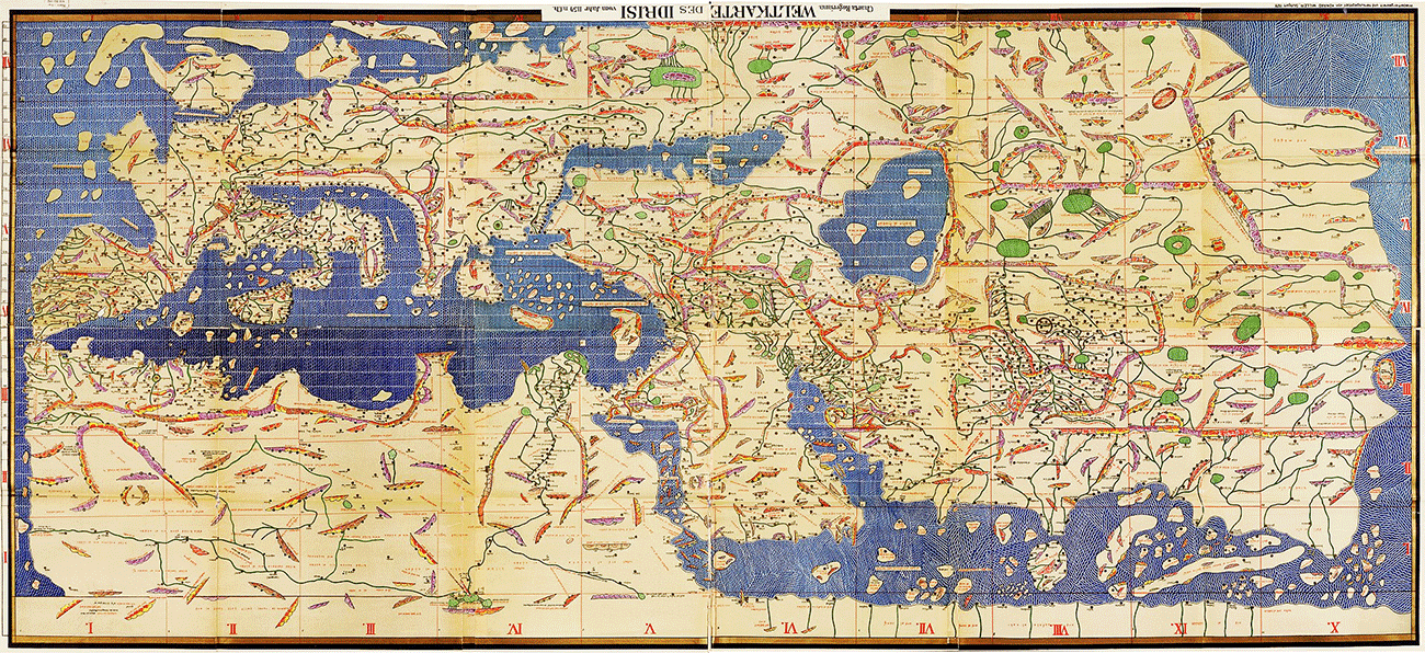
century. The second age is summed up in the work of the Eastern sage Albyrouny and of Edrisi, the
Arabic Ptolemy (a.d. 1099-1154), who found a home at
the Christian Court of Roger of Sicily. In the far East and West alike, in
Spain and Morocco, in Khorassan and India, Moslem
science was now driven to take refuge among strangers on the decay of the
Caliphates of Bagdad and Cordova. The Ghaznevides Mahmoud and Massoud in the first half of the eleventh
century, attracted to their Court not only Firdusi and Avicenna, but Albyrouny, whose “Canon” became a
text-book of Mohammedan science, and who, for the range of his knowledge and
the trained subtlety of his mind, stands without a rival for his time. The
Spanish school, as resulting directly in Edrisi, half
Moslem, half Christian, like his teachers, is of still more interest. One of
its first traces may be found in the Latin translation of the Arab Almanack
made by Bishop Harib of Cordova in 961. It was
dedicated and presented to Caliph Hakem—one of our
clearest proofs of the conscious interworking of Catholic and Mahometan
philosophy in the age of Pope Sylvester II. and of our own St. Dunstan. A
century later, on the recapture of Toledo by Alfonso VI. (1084), an observatory
was built, served by Jews and Moslems, who had been steadily producing, through
the whole of the eleventh century, astronomical and geographical tables and
dictionaries. A whole tribe of commentators on place-names, on the climates and
constellations, and on geographical instruments was at work in this last age of
the Spanish Caliphate, and their results are brought together by Abou Hamid of
Granada and by Edrisi.
Born at Ceuta in 1099, this great geographer travelled
through Spain, France, the Western Mediterranean, and North Africa before
settling at the Norman Court of Palermo. Roger, the most civilised prince in Christendom, the final product of the great race of Robert Guiscard
and William the Conqueror, valued Edrisi at his
proper worth, refused to part with him, and employed men in every part of the
world to collect materials for his study. Thus the Moor gained, not only for
the Moslem world but for Southern Europe as well, an approximate knowledge even
of Norway, Sweden, Finland, and the coasts of the White Sea. His work,
dedicated to Roger and called after him, Al-Rojary,
was rewarded with a peerage, and it was as a Sicilian Count that he finished
his Celestial Sphere and Terrestrial Disc of silver, on which “was inscribed
all the circuit of the known world and all the rivers thereof”.
Each of his great Arabic predecessors, along with
Eratosthenes, Ptolemy, and Strabo, was welded into his system—the result of
fifteen years of abstract study, following some thirty of practical activity in
travel (the world divided by climates in the Greek manner, taking no account of
political divisions, or of those resting on language or religion. Each climate
was further subdivided into ten sections).
A special note may be made on Edrisi’s account of the voyage of the Lisbon “Wanderers” (“Maghrurins”)
some time before 1147, the date of the final Christian capture of the
Portuguese capital. For this is the earliest recorded voyage, since the rise of
Islam, definitely undertaken on the Western Ocean to learn what was on it and
what were its limits. The Wanderers, Edrisi tells us,
were eight in number, all related to one another. They built a transport boat,
took on board water and provisions for many months, and started with the first
east wind. After eleven days, they reached a sea whose thick waters exhaled a
fetid odour, concealed numerous reefs, and were but
faintly lighted. Fearing for their lives, they changed their course, steered
southwards twelve days, and so reached an island, possibly Madeira,—which they
called El Ghanam from the sheep found there, without
shepherd or anyone to tend them. On landing, they found a spring of running
water and some wild figs. They killed some sheep, but found the flesh so bitter
that they could not eat it, and only took the skins. Sailing south twelve more
days, they found an island with houses and cultivated fields, but as they
neared it they were surrounded, made prisoners, and carried in their own boats
to a city on the sea-shore, to a house where were men of tall stature and women
of great beauty. Here they stayed three days, and on the fourth came a man, the
King’s interpreter, who spoke Arabic, and asked them who they were and what
they wanted. They replied they were seeking out the wonders of the ocean and
its limits. At this the King laughed heartily, and said to the interpreter: “Tell
them my father once ordered some of his slaves to venture out on that sea and
after sailing across the breadth of it for a month, they found themselves
deprived of the light of the sun and returned without having learnt anything”.
Then the Wanderers were sent back to their prison till a west wind arose, when
they were blindfolded and put on board a boat, and after three days reached the
mainland of Africa. Here they were put ashore, with their hands tied, and so
left. They were released by the Berbers, and after their reappearance in Spain,
a “street at the foot of the hot bath in Lisbon”, concludes Edrisi,
“took the name of Street of the Wanderers”.
On the other extremity of the Moslem world, on the
south-east coast of Africa, there was more real progress. By Edrisi’s day that important addition of Arabic travellers and merchants to the geographical knowledge of
the world, by the remarkable trade-ventures of the Emosaids,
had been already made.
It had taken long in the making.
THE WORLD ACCORDING TO EDRISI
 |
About A.D. 742, ten years after the battle of Tours,
the Emosaid family, descended from Ali, cousin and
son-in-law of Mahomet, tried to make Said, their clan-chieftain, Ali's
great-grandson, Caliph at Damascus. The attempt was foiled, and the whole tribe
fled, sailed down the Red Sea and African coast, and established themselves as
traders in the Sea of India. First of all, Socotra seems to have been their
mart and capital, but before the end of the tenth century they had founded
merchant colonies at Melinda, Mombasa, and Mozambique, which, in their turn,
led to settlements on the opposite coasts of Asia. Thus the trade of the Indian
Ocean was secured for Islam, the first Moslem settlements arose in Malabar, and
when the Portuguese broke into this mare clausum, in 1497-8, they found a belt
of “Moorish” coast towns, from Magadoxo to Quiloa, controlling both the Indian and the inland African
trades, as Ibn Batuta had found in 1330.
By Edrisi’s day, moreover,
the steady persistence and self-evident results of Arabic overland exploration
had become recognised by a sort of “Traveller's Doctorate”. It was not enough for the highest knowledge
to study the Koran, and the Sunna, and the Greek philosophers at home; for a
perfect education, a man must have travelled at least through the length and
breadth of Islam. All the successors of Edrisi, in
the twelfth and thirteenth centuries, shew this mingling of science and
religion, of practical and speculative energy.
Tradition still governed Moslem thought, but there had
come into being a sort of half-acknowledged appendix to tradition, made up of
real observations on men and things. And in these observations, geographical
interest was the main factor.
The Life of Al Heravy of
Herat (1173-1215), the “Doctor Ubiquitus” of Islam in
the age of the Crusades, gives us a picture of another Massoudy.
The friend of the Emperor Manuel Comnenus, the “first
man among Christians”, Heravy seems able in his own
person to break down the partition wall of religious feud by the common
interest of science. In 1192 he was offered the patronage of the Crusading
princes, and Richard Cœur de Lion begged for the favour of an interview, and begged in vain. Heravy, who had been on one of his exploring journeys,
angrily refused to see the King whose men had broken his quiet and wasted his
time. Before his death, he had run over the world (men said) from China to the
Pyrenees and from Abyssinia to the Danube, "scribbling his name on every wall,"
and his survey of the Eastern Empire was the single matter in which Turks and
"Romans" made common cause,—for Greeks and Latins at Byzantium alike
read Heravy, like a Christian doctor. Another example
of the same catholic spirit is “Yacout the Roman”,
whose Dictionary, finished in the earlier half of the thirteenth century, was a
summary of geographical advance since Edrisi, like
the similar work of Ibn Said, of the same period.
But as a matter of fact, the balance both of knowledge
and power was now shifting from Islam to Christendom. The most daring and
successful travellers after the rise of the Mongols
were the Venetian Marco Polo and the Friar Preachers who revived Chinese
Christianity (1270-1350); Madeira and the Canaries (off Moslem Africa) were finally
rediscovered not by Arabic enterprise, but by the Italian Malocello in 1270, by the English Macham in the reign of our Edward III, and by
Portuguese ships under Genoese captains in 1341; in 1291 the Vivaldi ventured
beyond Cape Bojador, where no Moor had ever been,
except by force of storm, as in the doubtful story of Ibn Fatimah, who “first
saw the White Headland”, Cape Blanco, between Cape Bojador and Cape Verde.
In the fourteenth century the map of Edrisi was superseded by the new Italian plans and
coast-charts, or Portolani. As the Moslem world fell
into political disorder, its science declined. “Judicial astrology” seemed
gaining a stronger and stronger hold over Islam, and the irruption of the Turks
gradually resulted in the ruin of all the higher Moslem culture. Superstition
and barbarism shared the honour and the spoils of
this victory.
But two great names close the five hundred years of
Arab learning.
1. Ibn Batuta (c. 1330), who
made himself as much at home in China as in his native Morocco, is the last of
Mohammedan travellers of real importance. Though we
have only abridgments of his work left to us, Colonel Yule is well within his
rights in his deliberate judgment, “that it must rank at least as one of the
four chief guide books of the Middle Ages”, along with the Book of Ser Marco
Polo and the journals of the two Friar-travellers,
Friar Odoric and Friar William de Rubruquis.
2. With Abulfeda the Eastern
school of Moslem geography comes to an end, as the Western does with Ibn Batuta. In the early years of the fourteenth century he
rewrote the "story and description of the Land of Islam," with a
completeness quite encyclopedic. But his work has all the failings of a
compilation, however careful, in that, or any, age. It is based upon information,
not upon inspection; it is in no sense original. As it began in imitation, so
it ended. If it rejects Ptolemy, it is only to follow Strabo or someone else;
on all the mathematical and astronomical data its doctrine is according to the
Alexandrians of twelve hundred years before, and this last précis of the
science of a great race and a great religion can only be understood in the
light of its model—in Greek geography.
|
|
 |
 |
 |
